Environmentally important areas of Northern Caspian Sea
Обсудить в форуме Комментариев — 0
A. Khmelevsky (GIS-LAB), A. Knizhnikov
The article is under development.
If you are interested in more details on this project or data that was used or the methodology, feel free to contact authors. (They are ready to answer).
The project is the part of open joint initiative GIS-LAB-Caspinfo. It’s planned to expand our activities and results to the entire Caspian basin in the near future.
For understanding dynamics of Northern Caspian ecological condition it’s important to have comprehensive knowledge about objects that play main role in conservation and in development as well.
Unfortunately even objects that have strogn legislation basis are very often don’t have adequate or/and publicly accessible visual representation on cartographic materials.
The main mission of current project is to fill up such a gap. However many of the environmentally important objects have not been mapped yet. The results of the previous project were used as a basis for creation the current map version. (see “Mapping boundaries of Volga Delta wetland” in russian).

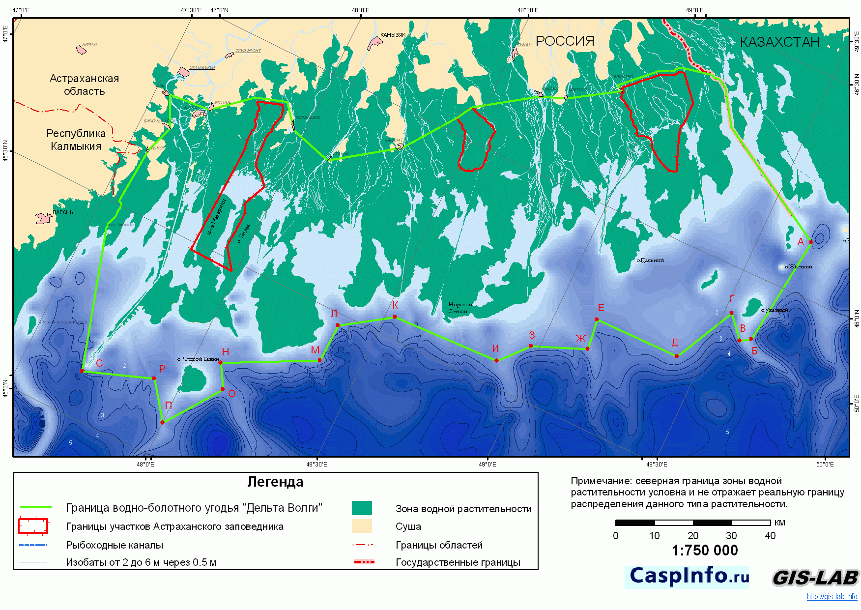
Fig.1 Environmentally important areas of Northern Caspian Sea
(download full-resolution map ,
1.7Mb)
1. Federal level protected nature areas
1.1 State Nature Reserves of Russian Federation
There are 2 state nature reserves located on the Russian part of the Northern Caspian Sea: Astrakhansky State Nature Biosphere Reserve (ABNR) and Dagestansky State Nature Reserve (DNR).
1.2 Federal preserves of Russian Federation
There is one preserve of federal level on the Russian part of the Northern Caspian Sea Region: Agrakhansky.
Boundaries of all federal protected nature areas are taken from [1]. The source for this data is appropriate legislation and official documents.
2. Wetlands of international value (Ramsar wetlands)
There only Ramsar wetland on the scheme is Volga Delta wetland, the boundaries of it were defined by appropriate legislation and official documents [2]. Detailed process of mapping Volga Delta boundaries is described in “Mapping boundaries of Volga Delta wetland” (in russian).
3. Special protected marine zones
Protected marine zones of Russia and Kazakhstan are shown on the scheme. Their boundaries are described in the legislation and official documents [3],[4],[5].
4. Concession areas of major companies
The boundaries of concession areas that shown on the scheme relate to these companies: KNK, LUKOIL [6] and AGIP [7].
5. Large oil&gas fields
Some of the perspective oil and gas fields of the Caspian Sea’s Kazakhstan sector (CSKS) are shown [8].
The project is open and we're ready to discuss the results of it with all interested, please send your remarks, suggestions, new data (legal texts) if available for addition to our map.
Data planned to be added:
We are interested in getting this data, please, contact us, if you have it and ready to share for distribution via open GIS. |
Data and publications used:
- Cartographic database on federal protected areas (©BCC, SEU, WRI). Подробнее
- Postanovlenie Glavi Administracii Astrakhanskoy oblasty ot 22 dekabrya 1997 №500 (Document in russian)
- Postanovlenie Soveta Ministrov Kazakhskoy SSR ot 30 aprelya 1974 goda № 252 “Ob obyavlenii zapovednoy zoni v severnoy chasti Kaspiyskogo moria”). (Document in russian)
- Postanovlenie Soveta Ministrov Kazakhskoy SSR ot 13 iula 1978 goda N284 "O vkluchenii v zapovednuiu zonu severnoy chasty Kaspiyskogo moria akvatorii i poymi reki Ural”. (Document in russian)
- Postanovlenie Soveta Ministrov RSFSR ot 31 janvaria 1975 g. N 78 “Ob obyavlenii zapovednoy zoni v severnoy chasti Kaspiyskogo moria”. (Document in russian)
- Bezrodniy U.G. Ekologicheskie problemi osvoenia mestorojdeniy uglevodorodov v severnoy melkovodnoy chasty Kaspiyskogo moria/ U.G. Bezrodniy, D.N.Katunin, A.A.Kurapov i dr.//Zaschita okrujauschey sredy v neftegazovom komplekse. 2003, №7. c.7-13.
- Ostrov Kashagan/ Specialnoe prilojenie KAZAKHSTAN// Neft i Kapital. 2001, №9(96). c. 36-38.
- Hozain vozmet ne menshe polovini v kajdom novom dobichnom proekte v kazakhstanskom sektore Kaspiya// Neft i Kapital. 2003, №9(74). c. 72-74
If you are interested in more details about this project, data or methodology, feel free to contact authors.
A. Khmelevsky (GIS-LAB), A. Knizhnikov (Crude Accountability, Caspinfo.ru)
Обсудить в форуме Комментариев — 0
Последнее обновление: September 09 2021


© GIS-Lab и авторы, 2002-2021. При использовании материалов сайта, ссылка на GIS-Lab и авторов обязательна. Содержание материалов - ответственность авторов. (подробнее).