Create point shapefile from a set of geotagged photos with Photo2Shape for QGIS
Обсудить в форуме Комментариев — 5Редактировать в вики
по адресу http://gis-lab.info/qa/photo2shape-eng.html
Work with geotagged photos in QGIS.
Create shapefile from a set of photos with coordinates in EXIF tags.
Installation notes[править]
Plugin is available via official repository.
Photo2Shape is designed for QGIS version 1.0.0 and higher. There are no dependencies, all necessary files are included in package.
You can obtain sources from our SVN:
svn co http://svn.gis-lab.info/photo2shape photo2shape
How does it work[править]
After plugin installation and startup by clicking
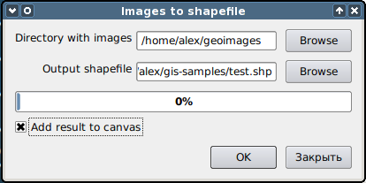
main window will appear
Now specify all necessary information:
- Enter path to the folder with photos
- Enter output shapefile filename (also it is possible to change encoding of attributes)
- To load new shapefile as layer in project check "Add result to canvas"
Shapefile creation will take some time (depends of number of photos). If there are photos without GPS tags they will be skipped and at end you will see list with skipped files and reason why it skipped.
In the attribute table following info will be recorded:
- full path to the file
- filename
- latitude
- longitude
- altitude
Contacts[править]
If you want report a bug or want make suggestion — use bugtracker.
Links[править]
Обсудить в форуме Комментариев — 5Редактировать в вики
Последнее обновление: 2014-05-14 22:41
Дата создания: 04.03.2010
Автор(ы): Александр Бруй
© GIS-Lab и авторы, 2002-2021. При использовании материалов сайта, ссылка на GIS-Lab и авторов обязательна. Содержание материалов - ответственность авторов. (подробнее).


