Applying single legend to multiple layers
Обсудить в форуме Комментариев — 1Редактировать в вики
по адресу http://gis-lab.info/qa/qgis-multiqml-eng.html
Tool background and description.
This tool can be used for applying a single legend file (qml) for multiple raster or vector layers in QGIS.
| Made by | Opensource GIS development and projects |
Installation notes[править]
Plugin is available via QGIS official repository.
MultiQML is under development and tested with QGIS 2.0 and higher.
You can obtain sources with this command:
git pull git@github.com:nextgis/MultiQML.git
How does it work[править]
After plugin installation and startup by clicking
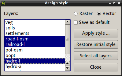
main window will appear:
At left there is a layers list which shows layers depending of the active selector «Raster» or «Vector». To apply style to layers:
- select layers in list (press "Select all layers" to select all available layers of the given type)
- if you want to make style default — check "Save as default" checkbox
- press "Apply style" button and select desired .qml
To restore original styles: select layers and press "Restore initial style".
Demo[править]
In this demo, the tool is used to apply a single legend to series of uniformly indexed raster, that have comparable color tables. During demo it is also used to use single min-max legends for series of USGS dems.
<object width="943" height="576">
 <param name="movie" value="/images/qgis-multiqml-01.swf">
 <embed src="https://wiki.gis-lab.info/images/qgis-multiqml-01.swf" width="943" height="576">
 </embed>
</object>
Contacts[править]
If you want report a bug or want make suggestion — use bugtracker. Also if you have a question about the script or plugin usage, you can contact us directly.
Links[править]
Обсудить в форуме Комментариев — 1Редактировать в вики
Последнее обновление: 2014-05-14 23:14
Дата создания: 10.01.2009
Автор(ы): Максим Дубинин
© GIS-Lab и авторы, 2002-2021. При использовании материалов сайта, ссылка на GIS-Lab и авторов обязательна. Содержание материалов - ответственность авторов. (подробнее).


