Georeferencing Toporama maps for Canada
Обсудить в форуме Комментариев — 0Редактировать в вики
по адресу http://gis-lab.info/qa/tfws-toporama.html
Canadians may be proud with their Toporama (http://toporama.cits.nrcan.gc.ca) maps. Whole country is covered with rather high quality maps. Maps are available at scales 1:250'000 and 1:50'000. And they are completely free. One thing that is confusing why nobody has made them usable with GIS?
Here are ESRI World files that can be used with any map downloaded from Toporama.
Download the map, convert it to something acceptable by Arcview\Arcinfo software like TIF, JPG (default GIF files are not supported) with any graphics software and put corresponding TFW file in the same directory. After loading it as a theme to Arcview you know get fully georeferenced map.
Download World files, Coordinate sytem: NAD83
|
|
|
|
|
|
NB:
- Extension of the world file should be made of raster file type.
For example: if it is TIF than the extension of world file should be TFW, if JPG than JGW. - Try to compress rasters with something like packbits or LZW (if you've license) algorithm, this will save some space.
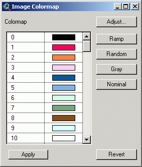
- Try to maintain uniform legend (colormap) for all maps, this will shrink filesize and bring you functionality of this Arcview extension (Transparent legend - Canada)
Colormap:
(Photoshop palette file for custom indexing)
As you can see:
0 - symbols, marks etc.
1 - highways
2 - local roads
3 - settlements
4 - hydro (borders)
5 - hydro (fill)
6 - veg (fill)
7 - veg (border)
8 - relief (hypsography)
9 - snow, ice (permafrost) areas
10 - white areas, not taken with any special feature
Обсудить в форуме Комментариев — 0Редактировать в вики
Последнее обновление: 2014-05-14 23:37
Дата создания: 11.12.2002
Автор(ы): Максим Дубинин
© GIS-Lab и авторы, 2002-2021. При использовании материалов сайта, ссылка на GIS-Lab и авторов обязательна. Содержание материалов - ответственность авторов. (подробнее).


